Scale drawing
A scale drawing represents an actual object but is different in size. Scale drawings are usually smaller than the object represented. The scale for a drawing is the ratio between the size of the drawing and what is represented. A map is an example of a scale drawing.
A map scale is a ratio between the dimensions on the map and the dimensions of the area it represents. The scale for the map shown below is in the lower right.
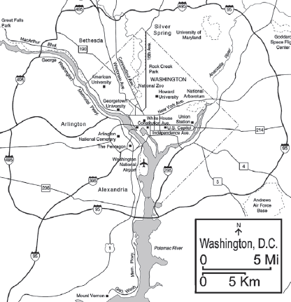
The scale of the map shows two distances, 5 mi and 5 km. The lengths of the line segments below these distances represents those distances on the map; a distance equal to the length of the 5 km line segment is equal to 5 km in the real area depicted by the map.
There are a few ways to use the scale on a map to determine distance, depending on how accurate you want to be. The simplest way is to use a straightedge, or even just your fingers to form the length of the line segment in the scale. For those who happen to have a set of calipers, just open the calipers to either the 5 mi or 5 km line segment. Then choose the two (or more) points you want to measure the distance between, and determine how many line segments it would take to cover that distance on the map. For the 5 km line segment, 1 length = 5 km, so a distance of 2 lengths on the map is equal to 10 km, and so on.
It is important to note that scale drawings are unlikely to be exactly accurate, so no matter how well you measure the lengths on the map, there is likely to be some error. However, to be most accurate, you could use a ruler to measure the line segments of the scale. For example, assume that the 5 km line segment measures 3 cm. In this case, 3 cm on the map would equal a real distance of 5 km. Knowing this, we can measure an exact length on the map using a ruler, then translate that into a real distance. A 6 cm distance on the map is equal to a real distance of 10 km.
Example
If the length of the 5 mi line segment on the scale of the map above is 8 cm long, how far apart in miles are two points on the map that are 5 cm apart on the map?
Solving this involves the use of proportions. We know that 8 cm on the map is equal to a real distance of 5 miles. Using proportions, we can determine how far 5 cm is as follows:

We solve this by cross multiplying:
8 × # = 5 × 5
8 × # = 25
# = 25 ÷ 8 = 3.125
Therfore, 5 cm on the map is equivalent to 3.125 mi.