Longitude
Longitude is a measurement that specifies the east-west position of a point in the geographic coordinate system. It is the counterpart to latitude. Longitude is measured in degrees (°) and ranges from -180° (west) to +180° (east).
Think of the geographic coordinate system dividing the Earth into a grid, with longitude representing east-west coordinates, and latitude representing north-south coordinates.
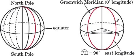
The Prime Meridian (Greenwich Meridian) represents 0° longitude in the geographic coordinate system, similar to the y-axis in the coordinate plane. Similarly, the equator represents 0° latitude.
Expressing longitude
The primary unit of longitude is the degree, but it can also be broken down into minutes (') and seconds ("):
1° = 60' = 3600"
Breaking the degrees down into minutes and seconds allows us to have more precision when referencing the latitude and longitude of locations around the world, since each degree of latitude and longitude may makes up to approximately 69 miles on Earth.
Longitude can be expressed in a number of different formats. Two common formats are:
Degrees minutes seconds: 37°46'29.7474" N 122°25'9.912" W
Decimal degrees: 37.77493° N 122.41942° W
We can also express the directions (N, S, E, W) using a positive or negative sign where positive latitude is north and negative latitude is south, and positive longitude is east and negative longitude is west. Using the same example as above, which are the coordinates for the city of San Francisco, we could write the coordinates as:
37.77493° -122.41942°
Did you know?
The Royal Observatory in Greenwich, England, was chosen as 0° longitude. The International Date Line is halfway around the world, at 180° longitude. Each time zone is about 15° of longitude, and the International Date Line marks the place that a new day begins.